An open day earlier this month showcased the latest advances in drone technology, which is likely to see growing use in fisheries enforcement across the world.
The UK Research and Innovation Fund, the government body that supports scientific developments and their commercial use, organised a demonstration day at an RAF base on the Lizard to showcase innovations in drone technology and their potential uses at sea.
Although attended by a range of representatives from the marine domain, including search and rescue, law enforcement officers and offshore energy developers, there seemed to be little in the way of representation from within the UK fisheries sector itself.
It was an interesting day. A key insight was that unlike the first generation of drones, the breakthroughs are now coming not in the drones themselves, but in their sensors and cameras, and in particular, the use of AI to allow the platforms to work out what is taking place at sea.
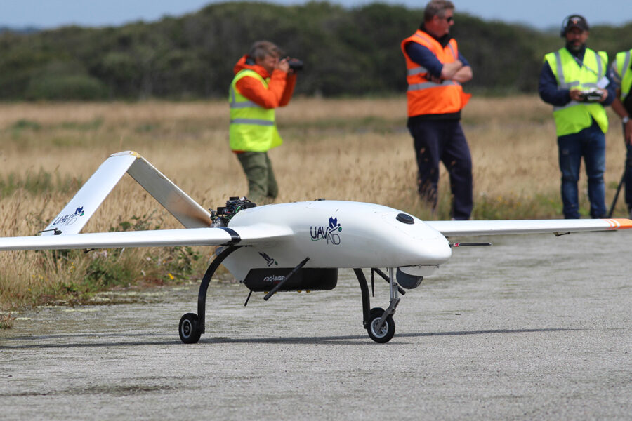
Two UK companies showcased their collaborative project, codenamed SeaWatch. This project has integrated UAVAID’s Hansard drone and Archangel Imaging’s Cerebella AI system into a single platform.
UAVAID’s fixed-wing drone is powered by a small petrol engine with over eight hours’ flight time, operable at up to 100km offshore, and capable of flying at 80km/h on cruise, but with sprint speeds of up to 130km/h. The unit has sufficient payload (carrying capacity) for both the AI-driven surveillance camera module and a nose-mounted observation camera controlled by the operator for target investigation.
There are no particular advances in the fixed-wing aircraft design itself. The real advances are in the communications systems and their integration into the platform. A communications, command and control (3C) system has been developed that allows real-time data transmission over radio-wave rather than through high-cost satellite communications.
This is further advanced by onboard computers using AI to interrogate images directly from the drone’s cameras to identify vessels.
The system is pre-loaded with a database of vessel images, which can then be compared by the system when spotting a vessel at sea. This is done onboard the drone in real time, and the identification is then compared with live AIS data. If there is an AIS match, the cross-referencing can be extended to confirm its status with respect to fishing permits and licences.
If there is no AIS match to the identified vessel, the drone operator is informed for further action. Additional databases such as lists of licensed or authorised vessels, the FAO fishing vessel finder and IMO registrations can be incorporated into the onboard computers.
Future development will investigate how the AI can be advanced to recognise the type of fishing gear aboard a boat, and estimate whether this is legal in the jurisdiction it is seen in. At any time, the system can of course also alert a shore-based operator, who can see the drone displays and interact with it if necessary.
The drone command system uses two human operators, one to programme the flights and manage data, the second qualified to fly the drone if required. In normal operations, the drone is given a predetermined flight plan. It is manoeuvred to the start point on a 250m section of road or runway, and then the automated system operates the take-off, predetermined flight plan and landing.
The drone has three separate communications systems for normal operations depending on the distance from the operator. These three systems depend on the drone being in a direct line from the operations base, so the further away from the operator, the higher the altitude needed for communications.
A fourth communications system is available through satellite communications in the event of radio control loss, and a final back-up is that the drone has a pre-planned location to which it will return if all communications fail. The drone is limited to operations in under 30 knots wind speed.
This combination of low-cost communications, multiple surface scanning cameras with real-time AI onboard processing, live AIS look-up and a manually operator controlled camera is claimed by the operators as being unique in the civil sphere.
For fisheries managers such as IFCAs, or anyone else thinking of using a drone at sea, it’s clear that the sophistication and capacity of surveillance drones is growing rapidly. UAVAID is hoping to have an electric version of its fixed-wing plane commercially available within two years. The two companies offer a range of options including outright sale, contract for supply (staff, training and hardware) with an option to purchase after an operating period, total charter for a period, and variations on the above.
What is going to be needed is extra training – also supplied by the companies – in drone operation, deployment, command systems, data management and maintenance. There will always be a need for patrol vessels, and a real human presence at sea, but the new technologies are likely to see this downgraded in future years, with considerable cost savings as a result.
The manufacturers are also marketing the system to support search and rescue and safety at sea applications, using the AI to locate and identify objects in the water in distress situations, and alerting the authorities to respond.
A second demonstration is planned for September. Anyone wishing to see the systems in operation, and learn more about them, is invited to register their interest at seawatchevent@gmail.com.
Fisheries drones for Welsh waters
The Welsh government, which has been plagued by accusations about the poor performance of its two patrol vessels, has taken the first steps to procure its own fisheries drones.
The government placed a contract notice on the public sector procurement website Sell2Wales asking for expressions of interest, saying that the aim of the procurement ‘was to improve the management and enforcement of Welsh fisheries’.
“This will be the first time we will use drones as part of our fisheries management,” a Welsh government spokesman told the BBC. “We already have access to a number of different tools and methods for managing fisheries including the operation of fisheries patrol vessels, access to vessel monitoring systems and statutory submissions of data.
“The drones will be for Welsh government primarily. However, we do carry out joint working with other agencies including Natural Resources Wales (NRW), and once the drones are operational we will consider their use for any joint exercises.”
Drones are already in increasing use in mapping inshore habitats, including monitoring by NRW of cockle beds and similar fisheries, but they have not been used in an enforcement role – unlike in England, where drones are already used in enforcement by several IFCAs.
Jim Evans, chairman of the Welsh Fishermen’s Association, told the BBC that the proposed use of drones by the Welsh government was ‘both news and surprising’.
He said every fishing vessel had monitoring devices, and that catches and method of capture were also recorded.
“It is unclear to me what additional value would be provided by drone surveillance, given that 90% of the Welsh fleet is predominantly inshore, small-scale and under-10m vessels using low-impact static gear,” said Mr Evans.
This story was taken from the latest issue of Fishing News. For more up-to-date and in-depth reports on the UK and Irish commercial fishing sector, subscribe to Fishing News here or buy the latest single issue for just £3.30 here.
Sign up to Fishing News’ FREE e-newsletter here.