The new high-res mapping tools being developed by the CABFishMan project will help small-scale fisheries defend their interests in a changing seascape, explains Elle Sibthorpe
As part of its work to develop tools for collaborative management of small-scale fisheries, the CABFishMan project has created a process for generating high- resolution maps of fishing activity. Such maps can be created using data submitted by fishermen, and have the potential to give them a stronger voice in management decisions around marine spatial planning.
Small-scale fisheries play a crucial role in supporting nearshore communities in the North East Atlantic – they sustain coastal economies through the provision of food and tourism, and contribute to the wellbeing and sense of place of local people.
Despite this, the support that they provide is increasingly being weighed up against competing demands for marine space, from offshore wind developments to designated areas for aquaculture and proposals for Marine Protected Areas. As these demands continue to grow, there is a need for evidence that demonstrates the value – both economic and social – that small-scale, inshore fisheries represent.
To properly understand and safeguard these fisheries in an increasingly competitive ocean space, stakeholders need to be equipped to communicate their value in a way that will resonate with decision-makers – namely, through evidence and data. Regrettably, however, there is a marked deficiency in useful information on small-scale fishing activity.
To bridge this knowledge gap, the CABFishMan project set out to create an evidence base by collecting the best available geographical data from specific case studies on small-scale fishing activity in the North East Atlantic.
A new method specific to small-scale fisheries was developed to analyse the activity of the sector, whilst taking into account the diversity of gears, target species and vessel types across Europe. Using this unique approach, the team collaborated with the UK, Irish, Spanish, French and Portuguese fishing industries to bring together diverse expertise and develop a method for transposing fisheries data into maps that demonstrate where small-scale fishing vessels are operating, at what time of year, and with what methods.
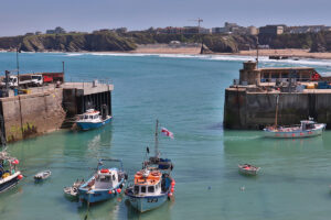
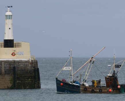
High-res mapping of fishing activity will give small-scale fleets in ports like Newquay the evidence they need to advocate for their fisheries. (Photo: Mindfully Wired Communications)
The researchers quickly realised that the maps needed to be highly detailed to truly meet fishermen’s needs, and that information on locally specific methods was needed to account for the nuances in fishing approaches – such as finding ways to link vessel tracking data with catches to understand the gear being used. The method for creating the maps, which are highly specific to small-scale fisheries, is the first of its kind, and will help to generate the best available evidence on the sector’s activity.
“If policy-makers want to access the best possible information on small-scale fisheries in the Atlantic area, CABFishMan is already compiling it,” said project lead Arantza Murillas. “We are producing a lot of very good, high-resolution information that will undoubtedly help policy- makers to understand their value and support management decisions as part of the Atlantic Area Strategy.”
As the data underpinning the maps grows, they will become ever more comprehensive. The intention is that this will give fishermen the evidence they need to advocate for their fisheries by demonstrating their fishing patterns, the methods they use, and the income that they provide. In this way, fishermen and fisheries managers should have a stronger voice in management decisions, particularly in the increasingly crowded landscape of marine spatial planning.
The more fishermen that contribute, the more refined the data will become, and the more accurate the maps will be. The project hopes that by giving fishermen the evidence they need to communicate the value of small-scale fisheries, politicians and decision-makers will start to value them too.
The maps are constantly evolving, and new data from fishermen is always welcome. The maps are available to view online via the project website, and will be integrated into the CABFishMan GeoTool – an open-access, online web tool designed to provide key evidence in support of management decisions for small-scale fisheries in the North East Atlantic.
The GeoTool and other resources will be showcased at the CABFishMan Final Symposium on 22 March, with online attendance available in the morning.
To find out more about the project, and register for the event, visit: cabfishman.net
NEXT WEEK: Tools to gauge the perceived impacts of different gears on marine environments
This story was taken from the latest issue of Fishing News. For more up-to-date and in-depth reports on the UK and Irish commercial fishing sector, subscribe to Fishing News here or buy the latest single issue for just £3.30 here.