REGULATION 8 OF THE INFRASTRUCTURE PLANNING (COMPULSORY ACQUISITION) REGULATIONS 2010
NOTICE OF PROPOSED CHANGES TO AN ACCEPTED DEVELOPMENT CONSENT ORDER
Notice is hereby given that Five Estuaries Offshore Wind Farm Limited (“the Applicant”) (registered office at Windmill Hill Business Park, Whitehill Way, Swindon, SN5 6PB) has made an application to amend the Development Consent Order (“DCO”) application as made, including changes to the areas of land which would be subject to compulsory acquisition.
The Secretary of State for Energy Security and Net Zero accepted an application (“the Application”) by the Applicant for a Development Consent Order under the Planning Act 2008 (“the Act”) on 22 April 2024 (application reference number: EN010115).
Summary Of the Project
The Application is for development consent to construct, operate, maintain, and decommission an offshore wind farm known as the Five Estuaries Offshore Wind Farm (“the Project”), and the associated development to connect the offshore wind farm to the national grid. The Project is a proposed extension to the operational Galloper Offshore Wind Farm situated off the coast of Suffolk.
The Project includes provision for the construction, operation, maintenance and decommissioning of an offshore wind farm located approximately 37 kilometres off the coast of Suffolk at its closest point in the southern North Sea; including up to 79 wind turbine generators and associated infrastructure making landfall at Sandy Point between Frinton-on-Sea and Holland-on-Sea in Essex, the installation of underground cables, and the construction of an electrical substation and associated infrastructure to the west of Little Bromley to connect the development to National Grid’s proposed East Anglia Connection Node substation. The Project includes provisions for the installation of additional underground ducts to be utilised by a separate project with a similar proposed landfall and connection point. The Project also includes provision for the construction, operation, maintenance, and eventual removal of habitat improvement measures for lesser black-backed gulls at a site on Orford Ness in East Suffolk.
Plans showing the onshore and offshore locations of the wind farm and associated infrastructure form part of the Application (Examination library reference APP-006 for the onshore location plan and APP-007 for the offshore location plan), which can be viewed on the Planning Inspectorates website under the documents tab:
https://national-infrastructure-consenting.planninginspectorate.gov.uk/projects/EN010115
As the proposed wind farm will have a generating capacity in excess of 100MW, it is classified as a Nationally Significant Infrastructure Project (NSIP) pursuant to sections 14(1)(a) and 15(3) of the Act. Development consent is therefore required for the Project.
The Development Consent Order would, if granted, authorise the compulsory acquisition of land, interests in land and rights over land, and the powers to use land permanently and temporarily. The Development Consent Order would also authorise alterations to the public highway network, the construction of temporary construction and permanent access routes, the temporary stopping up and / or management of the public highway, public rights of way and street works, and the application and / or disapplication of legislation.
SUMMARY OF CHANGES FOR ADDITIONAL LAND AND REASONS WHY IT IS REQUIRED
On 10 October 2024 the Applicant submitted the Change Request, which was accepted for Examination on 22 October 2024.The Change Request sets out 10 changes to the Application as accepted. These are detailed in the Report on Proposed Changes [AS-057]. Six of those changes involve an increase in the area of land subject to compulsory acquisition powers (Additional Land). Only these elements are being consulted on; each is summarised below. The Additional Land included within the Change Request is required as a consequence of ongoing consultation with landowners and statutory undertakers. Detail of the reason for each change is set out in the summary of the change below.
The Applicant considers that none of the proposed changes, either individually or cumulatively, would have the potential to give rise to any new or materially different likely significant effects to those reported in the Environmental Statement.
Proposed Change 2: Change to Mean High Water Springs
Revisions to the extent of Work Nos. 2A and 3 at the transition between the proposed offshore and onshore works arising from a recent periodic review by the Ordnance Survey of the Mean Low and High Water Springs water levels. The making of this change would alter the areas subject to compulsory acquisition for Land Plots 01-007, 01-008 and 02-001 and introduce a new plot 02-001A subject to compulsory powers. This Additional Land would total 24 square metres (m2).
Proposed Change 4: Additions to the Order Limits for haul roads
This seeks to increase the extent of the haul routes Work No. 7E by approximately 1,716 m2 and Work No. 9C by approximately 7,800 m2 in order to provide additional flexibility for reducing interactions (including with farming operations) and locating any off-route haul road in this location as far away as possible from the proposed Thorpe Park Solar Farm. This Additional Land is in Land Plots 05-008 (west of Pork Lane, Great Holland) and 07-002 (south of Walton Road, Thorpe-Le-Soken).
Proposed Change 5: Changes to the Order Limits in Bentley Road
To correct discrepancies between the proposed Order Limits and the Ordnance Survey map base and correct drawing errors, the extent of the works subject to Work Nos. 13 and 13A is increased in four locations. The largest of those increases would be approximately 0.24 m2. There would be Additional Land in respect of Land Plots 14-035, 14-036, 15-002 and 15-010 (all situated in the vicinity of Bentley Road).
Proposed Change 6: Additional construction access for Work Number 15D to the south of Ardleigh Road
A new construction access point has been added to access Work No. 15D to the south of Ardleigh Road by the Applicant to support the construction of the operational drainage connection. This additional access requires Additional Land of approximately 10 m2 relating to Land Plot 17-008 (Ardleigh Road).
Proposed Change 9: Changes to the Order Limits in relation to the proposed Lesser Black-Backed Gull compensation area at Orford Ness
Under this change the Applicant is seeking to amend the extent of the lesser black-backed gull compensation area subject to Work No. 18B. The proposed amendments would reduce the overall area affected and remove from the Order Limits: 1) the Norfolk Projects/Scottish Power Renewables lesser black-backed gull compensation area; and 2) the shingle bank on the eastern edge of Orford Ness.
Although reducing the total land affected, there would be 23471.45 m2 of Additional Land relating to Land Plot 20-003. This land is required to provide the 6 hectare site necessary to deliver the Lesser Black Backed Gull compensation measure.
Proposed Change 10: Changes to the operational access for the Proposed Development
At the request of the landowner, at Swan Road, removing an operational access connecting Work No. 10 with the public highway (occupying Land Plot 09-023) and replacing it with an alternative access to the south. Additional Land within a new Land Plot numbered 09-023. A revision to the access between Work No. 11 and Colchester Road is proposed to ensure this access reaches the public highway. This results in Additional Land in respect of Land Plot 12-005 by approximately 0.035 m2.
Statement on funding for the Additional Land
The Change Request does not have any material implications for the Funding Statement [APP-029]. The Funding Statement sets out how the compulsory acquisition of rights over land will be funded and the same mechanisms for funding will apply to the compulsory acquisition of rights over the Additional Land.
COPIES OF THE DOCUMENTS
Copies of the Change Request documents, which include the Report on Proposed Changes [AS-057] along with copies of the updated Land Plans [AS-019], Statement of Reasons [AS-037], Book of Reference [AS-063], draft Development Consent Order [AS-031], Explanatory Memorandum [AS-033] and Land Rights Trackers [AS-059] relating to the proposed changes and the maps showing the Additional Land are available to view free of change online in the Documents section the Planning Inspectorate’s webpage for the Project:
https://national-infrastructure-consenting. planninginspectorate.gov.uk/projects/EN010115 within the Documents tab.
The documents listed above can be viewed electronically, free of charge, at the following libraries until 16 December 2024.
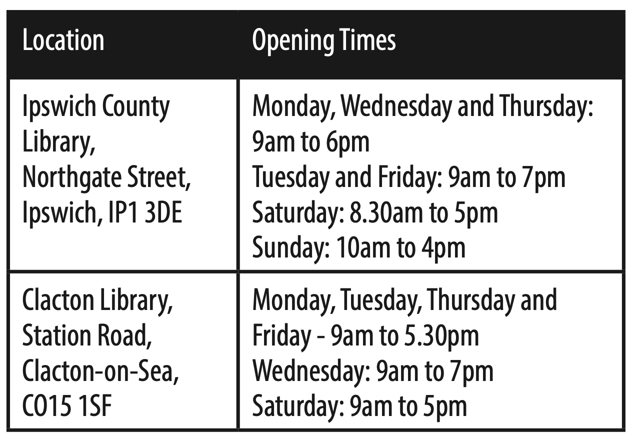
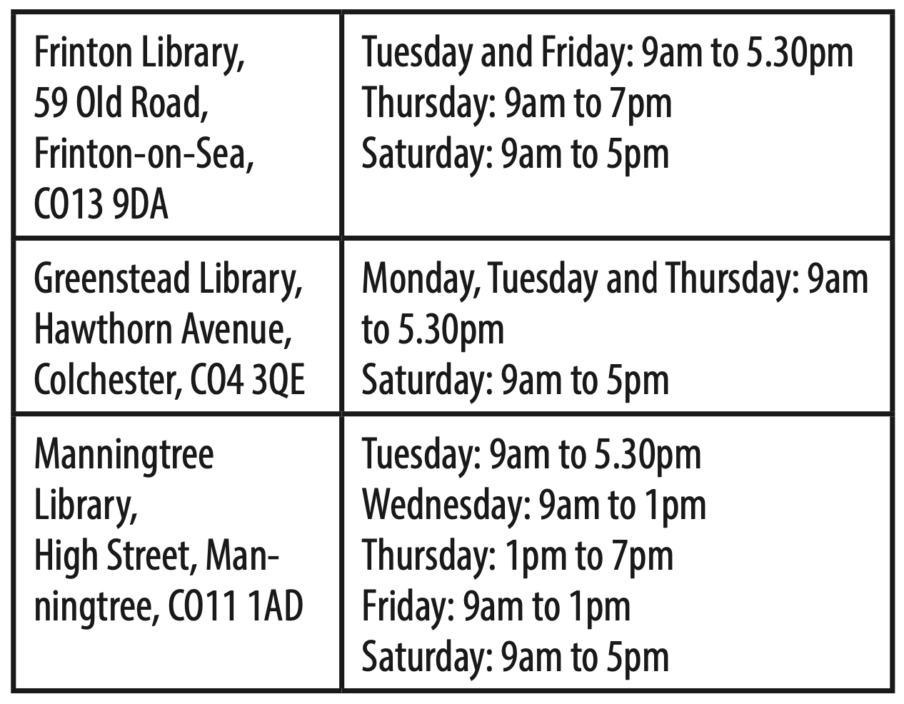
The documents related to the proposed change request can be made available in printed format on request at a cost of up to £1,000. Requests for alternative formats (braille, other languages, etc) will be considered on a case-by-case basis. For all document requests, please contact the Applicant using the details at the end of this notice.
MAKING A RELEVANT REPRESENTATION ON THE CHANGE APPLICATION
Any person may make representations in relation to this change request to the Secretary of State (including giving notice of any interest in the Application or the land affected by it or making any comment on or objection to the Application).
Any representation relating to the Application must be submitted on a registration form and give the grounds on which it is made.
The Registration and Relevant Representation form will be made available by the Planning Inspectorate webpage for the Project:
Alternatively, if you would like to request a paper copy of the Registration and Relevant Representation Form, please telephone the Planning Inspectorate on 0303 444 5000.
Completed paper forms should be sent to The Planning Inspectorate, National Infrastructure Directorate, Temple Quay House, Temple Quay, Bristol BS1 6PN. The Planning Inspectorate reference for the Application (EN010115) should be quoted in any correspondence.
Representations must be received by the Planning Inspectorate by 11:59pm on 16 December 2024. Please allow enough time for delivery if submitting a representation by post.
It should be noted that personal data, such as the name of persons submitting representations will be published alongside any representation. Please note that all representations submitted will be published on the Planning Inspectorate’s website and will be subject to their privacy policy, found online here:
To find out more about the Project, you can visit the Applicant’s website at www. fiveestuaries.co.uk. You can contact the Applicant directly with questions about the Project using the contact information below:
Email: fiveestuaries@rwe.com
Telephone: 0333 880 5306
Find more public notices at Fishing News

