LOWER THAMES CROSSING
SECTIONS 91 AND 92 AND 93 OF THE PLANNING ACT 2008
RULE 13(6) OF THE INFRASTRUCTURE PLANNING
(EXAMINATION PROCEDURE) RULES 2010
NOTICE OF HEARINGS RELATING TO: A122 LOWER THAMES CROSSING PLANNING
INSPECTORATE REFERENCE: TR010032
NOTICE IS HEREBY GIVEN that, at the dates, times and locations set out below, issue specific hearings and compulsory acquisition hearings will be held by the Examining Authority (appointed by the Secretary of State) for the examination of the application made by National Highways for a Development Consent Order (“the DCO”) for the Lower Thames Crossing (“the Application”).
The Application was made to the Secretary of State (via the Planning Inspectorate) under sections 14, 22 and 37 of the Planning Act 2008 on 31 October 2022 and was accepted by the Planning Inspectorate for examination on 28 November 2022. The Application has been given the Planning Inspectorate reference number TR010032.
SUMMARY OF THE PROJECT
The Application seeks development consent for the A122 Lower Thames Crossing located within ten administrative areas: Brentwood Borough Council, Dartford Borough Council, Essex County Council, Gravesham Borough Council, Kent County Council, London Borough of Havering, Maidstone Borough Council, Medway Council, Thurrock Council and Tonbridge and Malling Borough Council. The Project would provide a new road connection between the A2 and M2 in Kent, east of Gravesend, crossing under the River Thames through two bored tunnels, and joining the M25 south of junction 29, as set out in the plans which accompany the Application.
The main aspects of the Project comprise:
- A new road, the A122, approximately 23km long connecting to the existing road network from the A2/M2 to the M25:
- 4.25km of the new road would be in two tunnels, one southbound and one northbound;
- the new road would have three lanes in both directions, except for link roads, stretches of the carriageway through junctions and the southbound carriageway from the M25 to the junction with the A13/A1089, which would be two lanes;
- a maximum speed limit of 70mph would apply to the new road;
- the new road would be an all-purpose trunk road, with additional vehicle restrictions imposed and managed through signage so that walkers, cyclists, horse-riders and slow-moving vehicles would be prohibited;
- Junctions are proposed at the following locations: the A2 to the southeast of Gravesend; the A13/A1089 in Thurrock; and the M25 between junctions 29 and 30.
- Modifications will be made to a number of local roads to accommodate the new road, and modifications will be made to the A2, the A13 and the M25 to connect with the A122. There would also be adjustments to a number of public rights of way, used by walkers, cyclists, and horse riders.
- New structures will be constructed, and changes made to existing ones (including bridges, buildings, tunnel entrances and viaducts) along the length of the new road and the modified roads.
- Construction of the Project would also require the diversion of a number of utilities, including gas pipelines, overhead and underground electricity cables, as well as water supplies and telecommunications assets.
If the DCO is made by the Secretary of State, it would allow National Highways, for the purpose of constructing, operating and maintaining the Project, to acquire compulsorily interests in and rights over land, including the power to create and acquire new rights over land, and to take possession of and to use land temporarily.
The DCO would also make provision for development, which would constitute associated development together with other ancillary matters, including road user charging, the diversion and stopping up of lengths of existing highways and private means of access in the vicinity of the Project route, the classification of highways including trunking and the application of speed limits, the provision of byelaws applying to the tunnel and tunnel approaches, as well as the application, disapplication and modification of legislation relating to the Project.
HEARINGS
Based on the Updated Rule 8 Letter, those hearings taking place in November 2023 are provisionally to be held at the locations, dates and times shown below. A set of agendas will be published by the Examining Authority in due course, which will advise of any changes to the details shown below
The order of these hearings is to be confirmed by the Planning Inspectorate but will be comprised of issue specific hearings (ISH), compulsory acquisition hearings (CAH) and open-floor hearings (OFH).
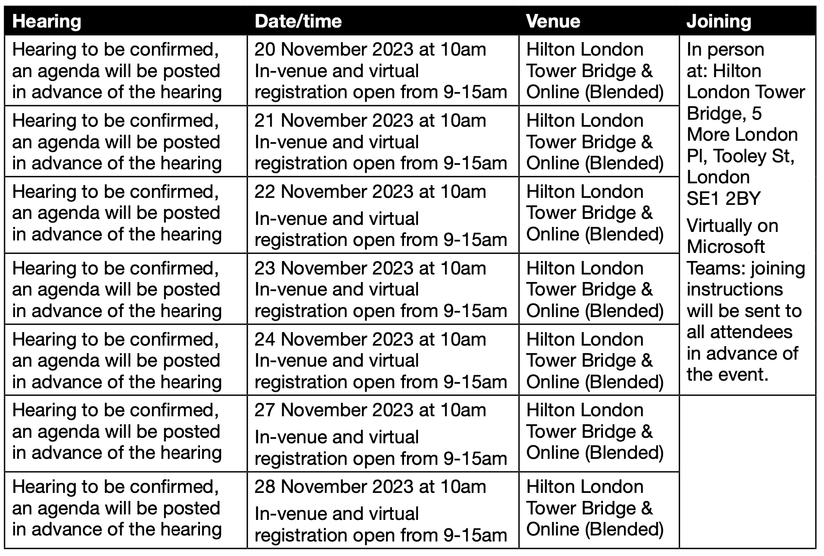
If you wish to attend and/or participate in any or all of the above hearings, please register on the Planning Inspectorate’s project webpage. If you simply wish to observe the hearings virtually then you do not need to register as you will be able to watch a livestream of the events. The physical venues above will also be open to the public.
The Planning Inspectorate’s project webpage which is available using the following link: https:// infrastructure.planninginspectorate.gov.uk/projects/south-east/lower-thames-crossing/
A link to the livestream will be made available on the project webpage shortly before the event is scheduled to begin. Full instructions on how to join online or by telephone will be provided in advance to those who have pre-registered.
Any hearings further to those listed above will be advertised by one or more further notices.
In accordance with Rule 13(3) of Infrastructure Planning (Examination Procedure) Rules 2010 the Planning Inspectorate will also notify interested parties of the date, time and place fixed for each hearing.
For more information on these hearings, the examination of the Application and full timetable (and any amendments to it), including how and when to register to speak at the hearings and how and when to make written submissions, please contact the Planning Inspectorate using the details below, or visit its website where procedural decisions and notices of hearings are available to download. https://infrastructure.planninginspectorate.gov.uk/projects/south-east/lower-thames-crossing/
COPIES OF THE APPLICATION DOCUMENTS
The application form and accompanying documents, plans, and maps, including the Environment Statement can be viewed electronically and free of charge on the Project page, under the documents tab of the Planning Inspectorate’s National Infrastructure Planning website: https://infrastructure.planninginspectorate.gov.uk/projects/south-east/lower-thames-crossing/
Full copies of the Application documents can also be viewed at the following public locations:
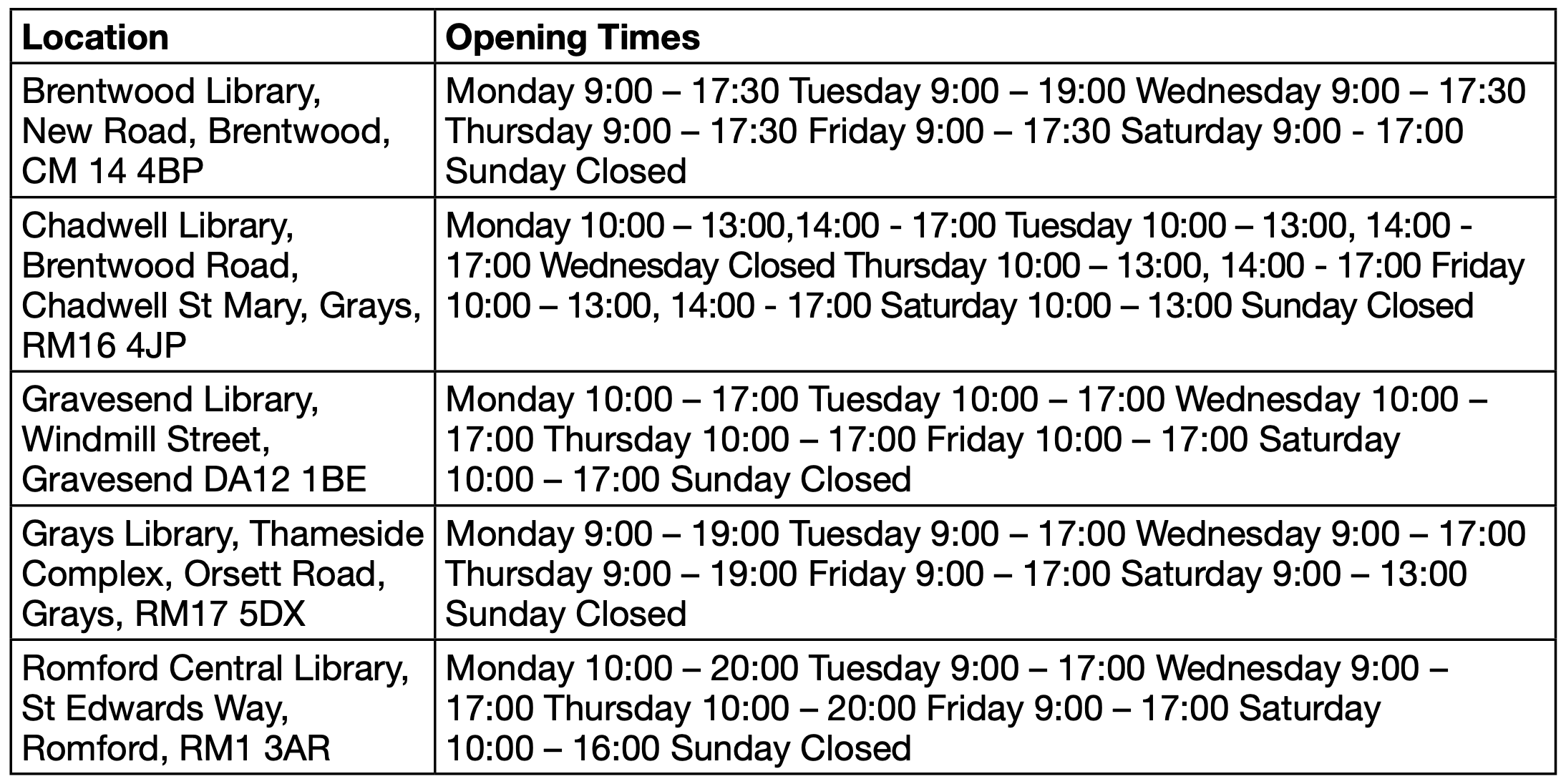
Venue copying charges will apply. The details of opening times above are correct at the time of this notice but could be subject to variations such as for public holidays. You are advised to check with the venue in question prior to attending.
The Application documents can also be viewed online at libraries with internet facilities, using the web address above. Libraries in the vicinity of the proposed route have been supplied with a poster explaining how documents can be accessed
ACCOMPANIED SITE INSPECTION
In addition to the above hearings, the Examining Authority has arranged an accompanied site inspection in the company of interested parties. This will take place in November 2023 and more details for this accompanied site inspection, including an itinerary will be published in advance of the site visit on the Planning Inspectorate’s project website: https://infrastructure. planninginspectorate.gov.uk/projects/south-east/lower-thames-crossing/
FURTHER INFORMATION
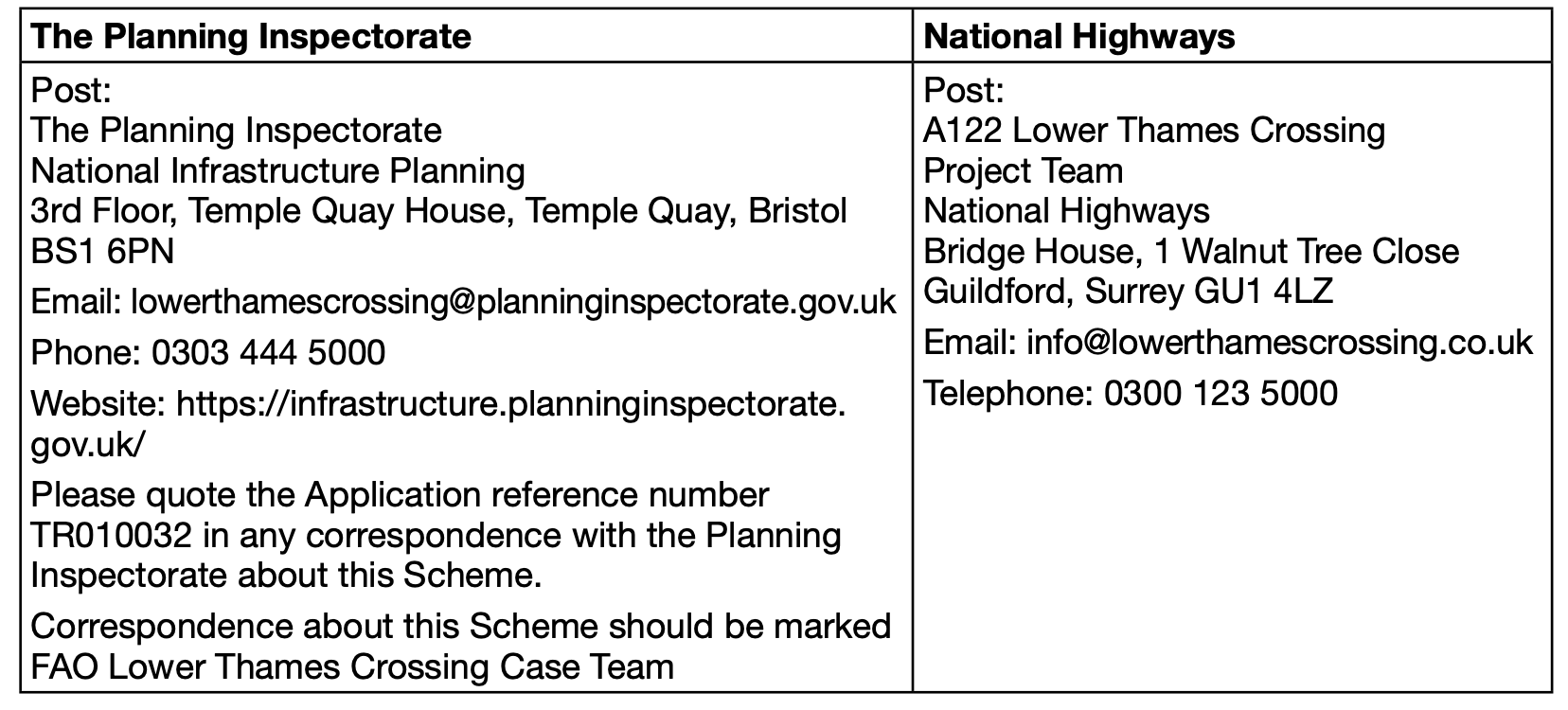
Further information about the Application and the hearings, how to take part in the Examination and any other matters covered in this notice may be obtained from the Planning Inspectorate or National Highways using the following contact details: