NATIONAL GRID ELECTRICITY TRANSMISSION PLC | SECTION 48 OF THE PLANNING ACT 2008 (AS AMENDED) REGULATION 4, THE INFRASTRUCTURE PLANNING (APPLICATIONS: PRESCRIBED FORMS AND PROCEDURE) REGULATIONS 2009 NOTICE PUBLICISING A PROPOSED APPLICATION FOR A DEVELOPMENT CONSENT ORDER FOR THE SEA LINK PROJECT
Notice is hereby given that National Grid Electricity Transmission plc (NGET) of National Grid House, Warwick Technology Park, Gallows Hill, Warwick, CV34 6DA intends to apply to the Secretary of State for Energy Security and Net Zero for a Development Consent Order (DCO) under Section 37 of the Planning Act 2008 (as amended) (the Act) to authorise the construction of the Sea Link Project. This is the second time the Notice of the Application has been published as it was originally published in October 2023 as part of a statutory consultation for the project.
The Sea Link Project (‘proposed Project’) involves the reinforcement of the electricity transmission network between Suffolk and Kent, predominantly via offshore High Voltage Direct Current (HVDC) link, but with onshore elements to connect into the transmission network. The proposed Project is split into three key elements, as follows.
The Suffolk Onshore Scheme
- A connection from the existing transmission network via Friston Substation, including the substation itself. Friston Substation already has development consent as part of other third-party projects. If Friston Substation has already been constructed under another consent, only a connection into the substation would be constructed by the Sea Link project.
- A high voltage alternating current (HVAC) underground cable of approximately 1.9 km in length between the proposed Friston Substation and a proposed converter station (below).
- A 2 GW HVDC converter station up to 26 m high plus external equipment (such as lightning protection, safety rails for maintenance works, ventilation equipment, aerials, similar small scale operational plant, or other roof treatment) near Saxmundham.
- A HVDC underground cable connection of approximately 10 km in length between the proposed converter station near Saxmundham, and a transition joint bay (TJB) approximately 900 m inshore from a landfall point (below) where the cable transitions from onshore to offshore technology.
- A landfall on the Suffolk coast (between Aldeburgh and Thorpeness).
The Offshore Scheme
- Approximately 122 km of subsea HVDC cable, running between the Suffolk landfall location (between Aldeburgh and Thorpeness), and the Kent landfall location at Pegwell Bay.
The Kent Onshore Scheme
- A landfall point on the Kent coast at Pegwell Bay.
- A TJB approximately 800 m inshore to transition from offshore HVDC cable to onshore HVDC cable, before the cable continues underground for approximately 1.7 km to a proposed new converter station (below).
- A 2 GW HVDC converter station, up to 28 m high plus external equipment (such as lightning protection, safety rails for maintenance works, ventilation equipment, aerials, and similar small scale operational plant, or other roof treatment), near Minster. A new substation would be located immediately adjacent.
- Removal of approximately 2.2 km of existing HVAC overhead line, and installation of approximately 3.5 km of new HVAC overhead line from the converter station and substation near Minster and the existing Richborough to Canterbury overhead line.
The Proposed Project also includes modifications to sections of existing overhead lines in Suffolk (only if Friston Substation is not built under other existing third party consents) and Kent, diversions of third-party assets, and land drainage from the construction and operational footprint. It also includes opportunities for environmental mitigation, compensation and enhancement. The construction phase will involve various temporary construction activities including overhead line diversions, use of temporary towers or masts, working areas for construction equipment and machinery, site offices, parking spaces, storage, accesses, bellmouths, and haul roads, as well as watercourse crossings and the diversion of public rights of way (PROWs).The proposed development will include other required works, for example, temporary access roads, highway works, temporary works compounds, work sites and ancillary works.
The proposed application will seek authorisation for the compulsory acquisition of land and interests in and rights over land, overriding easements and other rights, the temporary use of land, and other ancillary powers.
The proposed project is an Environmental Impact Assessment (EIA) development, as defined by The Infrastructure Planning (Environmental Impact Assessment) Regulations 2017. An Environmental Statement will therefore be submitted as part of the proposed application, which will contain information about the environmental effects of the proposed project.
A further consultation will take place between 08 July 2024 and 11 August 2024 (23:59).
Following the previous statutory consultation which took place between 24 October and 18 December 2023 NGET has been reviewing feedback and making a series of refinements to Project proposals and the further consultation will focus on these refinements. The proposed changes are grouped into four categories that include permanent infrastructure; construction and maintenance work; mitigation, enhancements and approach to biodiversity net gain; and strategy for coordination.
The changes to the proposals in Suffolk include an alteration to the cable route north of Aldeburgh; confirmation of the proposed access route to the Saxmundham converter station, and alterations to the route and associated bridge over the River Fromus; various changes to construction and maintenance access routes, compounds, and temporary overhead line diversions; and areas of newly introduced environmental mitigation and enhancement. The strategy for coordination with other third-party proposals in the vicinity has also evolved. Changes to the proposals offshore include refinements to the cable route; the introduction of additional marine areas for construction vessel manoeuvring; and changes to the approach for backfilling marine trenches. Changes in Kent include an increase of the overall maximum height of the converter station; confirmation of the use of standard pylon type for the AC connection; the introduction of a further construction and maintenance access route off Sandwich Road via the former hoverport; various other changes to construction and maintenance access routes, compounds, and temporary overhead line diversions; and areas of newly introduced environmental mitigation and enhancement. This further consultation includes details of the construction methodology including working hours.
We have also made a range of smaller changes to our proposals. These include various refinements, including reductions and increases to the size of the draft order limits, which comprise the land we would need to build and operate Sea Link.
All documents, plans and maps showing the nature and location of the proposed application and changes proposed as part of the further consultation, including the additional preliminary environmental information, will be available to download free of charge from 08 July 2024 until 11 August 2024 on www.nationalgrid.com/sealink (via the document library page).
Reference copies of the documents, plans and maps showing the nature and location of the proposed development will also be available to view free of charge from 08 July 2024 at the following locations in the vicinity of the project for the duration of the consultation (until 11 August 2024).
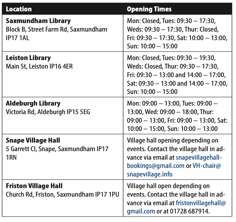
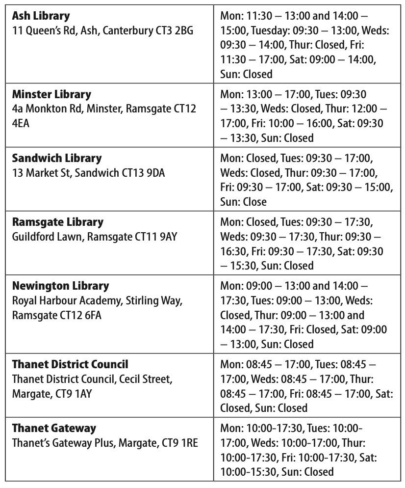
Materials will be available to view during the opening hours listed above, except in circumstances outside of NGET’s control which prevent the locations specified from opening.
Requests for paper copies of the documents, plans and maps will be reviewed on a case by-case basis. To cover printing costs a reasonable copying charge may apply, to be paid for by the recipient and up-to a maximum value of £300 for the whole suite of consultation documents. These can be requested by contacting the Project Team via the details at the bottom of this notice.
How to respond to the consultation
The consultation is running between 08 July 2024 and 23:59 on 11 August 2024.
Responses to the consultation can be submitted in the following ways:
- by post at Freepost SEA LINK
- by email (contact@sealink.nationalgrid.com)
National Grid must receive all responses by 23:59 on 11 August (or 16 August 2024 for postal feedback) to ensure their consideration. Please note that responses are likely to be made public, but that contact/personal details will be redacted.
When deciding on the final form of the proposed application for a development consent order for the proposed project, National Grid will take into account any response to this publicity or the consultation that is received before the specified deadline.
National Grid may be required to make copies of representations available to the Secretary of State. However, National Grid will request that personal details are not placed on the public record. Personal details will be held securely in accordance with the Data Protection Act 2018 and will be used solely in connection with the consultation process and the development of this project and, except as noted above, will not be disclosed to any third parties.
If you have any questions about the project or the consultation, please get in touch:
Email: contact@sealink.nationalgrid.com
Telephone: 0808 134 9569
Find more public notices at Fishing News

