Section 56 Planning Act 2008
Regulation 9 of The Infrastructure Planning (Applications: Prescribed Forms and Procedure) Regulations 2009
Notice of Acceptance of an Application for a Development Consent Order
A122 Lower Thames Crossing
Notice is hereby given that the Secretary of State has accepted an application by National Highways Limited of Bridge House, 1 Walnut Tree Close, Guildford, GU1 4LZ (“the Applicant”) for a Development Consent Order (“DCO”) under the Planning Act 2008 (“the Application”). The Application was submitted by National Highways to the Secretary of State c/o the Planning Inspectorate (“the Inspectorate”) on 31 October 2022 and was accepted for examination on 28 November 2022. The reference number applied to the Application by the Inspectorate is TR010032.
Summary of the Project
The DCO would authorise the A122 Lower Thames Crossing (the “Project”), located within ten administrative areas: Brentwood Borough Council, Dartford Borough Council, Essex County Council, Gravesham Borough Council, Kent County Council, London Borough of Havering, Maidstone Borough Council, Medway Council, Thurrock Council and Tonbridge and Malling Borough Council. The Project would provide a new road connection between the A2 and M2 in Kent, east of Gravesend, crossing under the River Thames through two bored tunnels, before joining the M25 south of junction 29, as set out in the plans which accompany the Application. The Project in summary involves:
- A new road, the A122, approximately 23km long connecting to the existing road network from the A2/M2 to the M25.
- 4.25km of the new road would be in two tunnels, one southbound and one northbound.
- The new road would have three lanes in both directions, except for link roads, stretches of the carriageway through junctions and the southbound carriageway from the M25 to the junction with the A13/A1089, which would be two lanes.
- a maximum speed limit of 70mph would apply to the new road.
- The new road would be an all-purpose trunk road, with additional vehicle restrictions imposed and managed through signage so that walkers, cyclists, horse-riders and slow-moving vehicles would be prohibited.
- Junctions are proposed at the following locations: the A2 to the south-east of Gravesend; the A13/A1089 in Thurrock; and the M25 between junctions 29 and 30.
- Modifications will be made to a number of local roads to accommodate the new road, and modifications to the A2, the A13 and the M25 to connect with the A122. There would also be adjustments to a number of public rights of way, used by walkers, cyclists, and horse riders.
- New structures will be constructed, and changes made to existing ones (including bridges, buildings, tunnel entrances and viaducts) along the length of the new road and the modified roads.
- Construction of the Project would also require the diversion of a number of utilities, including gas pipelines, overhead and underground electricity cables, as well as water supplies and telecommunications assets.
The DCO would authorise the compulsory acquisition of land, interests in land and rights over land, and the powers to use land permanently and temporarily for the construction, operation, and maintenance of the Project.
The DCO also includes provision for a number of ancillary matters, such as road user charging, the diversion and stopping up of lengths of existing highways and private means of access in the vicinity of the Project route, the classification of highways including trunking and the application of speed limits, the provision of byelaws applying to the tunnel and tunnel approaches, as well as the application, disapplication and modification of legislation relating to the Project.
A map showing the location of the Proposed Development forms part of the Application and can be viewed at the following link https://infrastructure.planninginspectorate.gov.uk/ projects/south-east/lower-thames-crossing/
Environmental Impact Assessment
The Project qualifies as Environmental Impact Assessment development
(“EIA development”) as defined by The Infrastructure Planning (Environmental Impact Assessment) Regulations 2017. The Application is therefore accompanied by an Environmental Statement.
Copies of Application Documents
The application form and accompanying documents, plans, and maps, including the Environment Statement can be viewed electronically and free of charge on the Project page, under the documents tab of the Planning Inspectorate’s National Infrastructure Planning website https://infrastructure.planninginspectorate.gov.uk/projects/south-east/lower- thames-crossing/. The documents will be available on that website during the relevant representation period and during the examination of the Project. These documents may
be viewed electronically using the link above by accessing the internet. Internet facilities
are available at various libraries in the vicinity of the Project, including those libraries listed below. For a full list of internet-enabled libraries in your area, contact your local authority.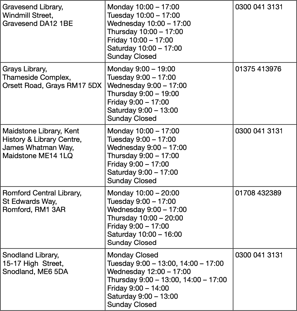
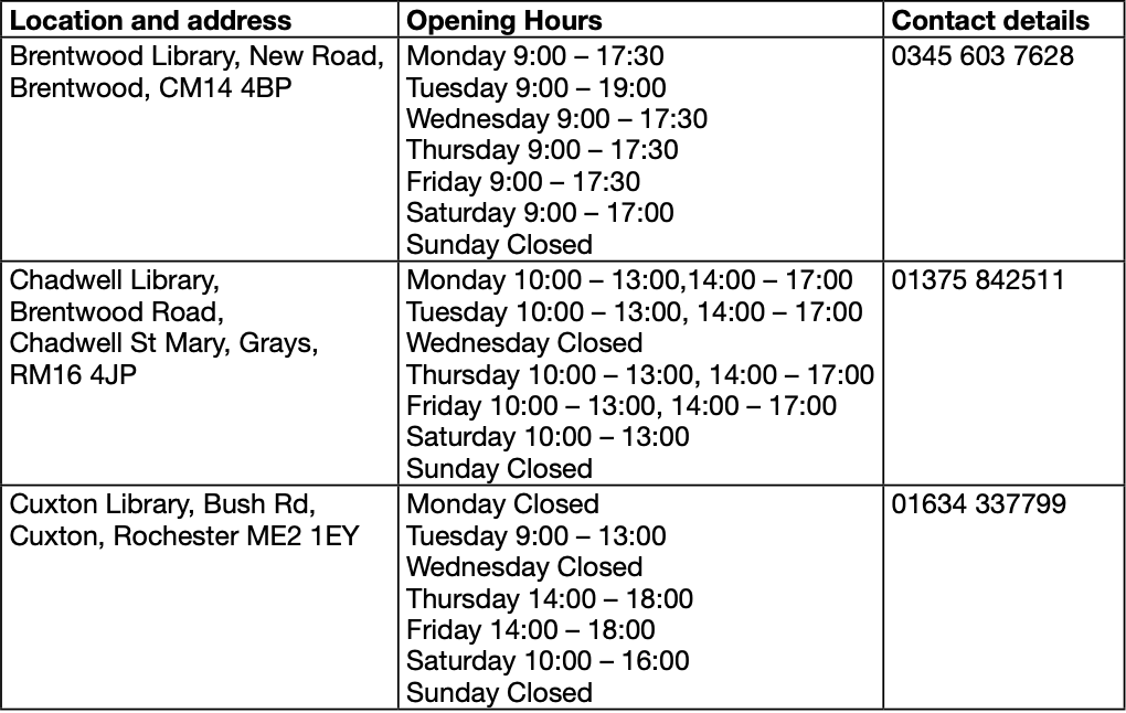
Please contact libraries in advance to arrange an appointment for computer access to view the documents electronically. The details of opening times above are correct at the time of this notice. You are therefore strongly advised to call a venue in advance before attending to confirm internet availability, opening hours and any restrictions in place.
Where appropriate, and subject to any public health restrictions, the Applicant may make further provision for venues where the application documents can be accessed. The Lower Thames Crossing website https://nationalhighways.co.uk/our-roads/lower-thames-crossing/ should be checked for details of such venues. Alternatively, please telephone 0300 123 5000 for details.
On request, a USB containing copies of all application documents can be provided free of charge and will be limited to one USB per household. A hard copy of the application documents can also be obtained for a charge of £15,000 inclusive of VAT (copies of individual documents are also available on request and a reasonable charge may apply). Hard copy requests will also be limited to one set per household. Details of how to request documents can be found at the end of this notice.
Making representations about the proposed DCO
The period for making representations starts on 9 January 2023 and will end at 11.59pm on 24 February 2023.
Any person may make representations on the Application to the Secretary of State (i.e.: giving notice of any interest in or objection to the Application). Any representation relating to the Application must be submitted on a Registration and Relevant Representation form and give the grounds on which it is made. The Inspectorate have issued detailed advice on registering as an interested party and making a relevant representation, to which you are advised to have regard. This Advice Note
(8.2 – How to Register to Participate in an Examination) is published on the National Infrastructure Planning website under ‘Legislation and Advice’ and can be found at: https://infrastructure.planninginspectorate.gov.uk/legislation-and-advice/advice-notes/
The Registration and Relevant Representation form will be made available by the Inspectorate once the registration/representation period has opened on the relevant page for the Application via the National Infrastructure Planning website https://infrastructure. planninginspectorate.gov.uk/projects/south-east/lower-thames-crossing/.
Alternatively, you can request a hard copy of the form by telephoning 0303 444 5000 quoting the name of the Application and the Inspectorate’s reference number TR010032. A completed hard copy form to be submitted to the Inspectorate should be sent to:
The Planning Inspectorate, National Infrastructure Planning 3rd Floor, Temple Quay House, Temple Quay, Bristol BS1 6PN
Please quote reference number TR010032 in all correspondence with the Inspectorate about this Application.
The period during which you can submit a Relevant Representation to the Inspectorate begins on 9 January 2023 and will end at 11.59pm on 24 February 2023. Please note that any submitted representations to the Inspectorate will be published on the National Infrastructure Planning website for the Application.
For enquiries in relation to the application form and the accompanying documents,
plans and maps and requests for application documents, please contact National Highways as follows:
Post:
A122 Lower Thames Crossing Project Team National Highways
Bridge House
1 Walnut Tree Close Guildford
Surrey GU1 4LZ
Email: ltc@nationalhighways.co.uk
Telephone: 0300 123 5000
Please note representations will be made public and will be subject to the Planning Inspectorate’s privacy policy at https://infrastructure.planninginspectorate.gov.uk/ application-process/frequently-asked-questions/gdpr-faq/